
Water mills at the island
Article Index
A) The origin
B) The left branch
C) The right branch
D) Description
E) The images
F) Bibliography and Credits
A) THE ORIGIN
 Since the second century mills were on the side of the Gianicolo that from St Peter in Montorio steeply slopes down to the Tiber; they were activated by the fall of the water that the emperor Traiano had derived from the area of the Sabatini mountains (pict. A1).
During the Goth siege of Rome in 537 AD, Vitige ordered the aqueducts cut in order to prevent the arrival of drinkable water to the city; this lack of water also stopped the operation of the Gianicolo mills. These were reactivated, in a new position, only in the XVII century when Pope Paul V Borghese (1607-1612) built the aqueduct that still has his name (Acqua Paola) conveying water from the lake of Bracciano (pict. A2).
 The forced inactivity of the Gianicolo mills gave birth to the Tiber floating mills: in fact, as Procopio of Cesarea testifies, the Byzantine general Belisario, sent by the emperor Giustiniano to garrison the city, used the river's current to move the first floating mills. He anchored to the banks two boats with a wheel between them; the wheel, activated by the current, drove the millstones located in the boats themselves.
The mills had been first located just downstream from Ponte Sisto, the bridge across the only part of the Tiber enclosed by walls on both sides and therefore protected from the military point of view; moreover this location is near the Gianicolo and this made the transport of the millstones easier.
From there the mills grew around the Tiber Island, thus becoming part of the Tiber landscape for more than 1300 years until the construction of the embankments.
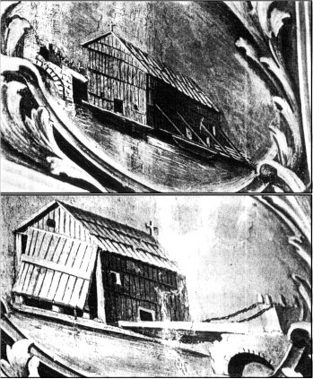
From some remnants recovered near the piers of the Ponte Neroniano, near Castel S.Angelo, (one millstone, a chain and some planks of the raft) it has been possible to reconstruct a scale model of the mill (pict. A3).
B) THE LEFT BRANCH
The oldest traces of the Tiber mills are found on the left branch of the river; it was, however, less used than the right one due to its reduced water flow.
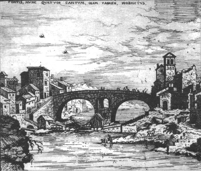 The first textual references to the mills are found in texts of the 1300s, but the first graphic evidence is a drawing by "Anonymous Escurialensis" (after a drawing by Giuliano da Sangallo), dated between 1485 and 1514 (pict. B1), that shows three mills on the Tiber's left branch just upstream from the Ponte Fabricio, and an engraving by Hieronymus Cock dated 1530-34 (pict. B2) that shows two mills, also just upstream from the Fabricio bridge, one anchored to the left bank and the other to the island.
All later images show a single mill, or two placed side by side, but located upstream, on the Regola bank.
 In particular two mills are shown by Silvestro Peruzzi (1564-65) and by Giovanni Maggi (1625) (pict. B3); Maggi drew them not to scale and located in front of S.Vincenzo and Anastasio at the Regola, further upstream than where they probably really were.
A single mill is indicated in the maps of Antonio Tempesta (1593), Matteo Greuter (1618), G.B.Falda (1676) (pict. B4) and G.B.Nolli (1748) (pict. B5).
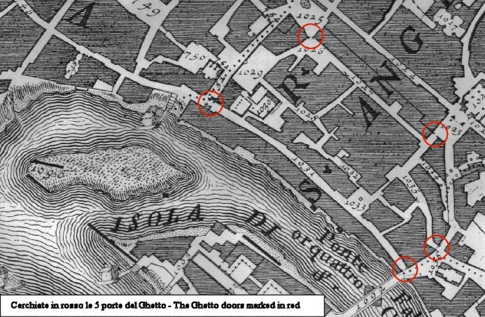
This mill is known (1620) as "mola di S.Andrea al Portone delli Hebrei" [mill of S.Andrea at the Door of the Jews], as it was located near one of the 5 doors, clearly visible in the Falda and Nolli maps, that enclosed the Jewish Ghetto constituted by Papal Bull in 1555. The doors were definitively unhinged only in 1848.
Andrea Chiesa, engineer from Bologna, appointed together with Gambarini to study the Tiber, also reported in 1745 that in the left branch of the river near the island there was only one mill, known as "Mola di Ghetto" [mill of the Ghetto], located in correspondence with the north end of the island and therefore near Monte Cenci as shown in the 1746 map (pict. B6).
The last citation of this mill is dated 1810; the mill, therefore, completely disappeared in the beginning of the 1800s.
 The last known mill on the Tiber's left branch is the so-called "mola terragna" [mill with foundations] located on the island (not floating). In a census it was numbered as 43 and 44 of "Via delle mole di S.Bartolomeo" [Street of the Mills of St Bartolomeo]. Starting in 1826 it is found, under the name of the "Giuditta" mill, in the records of the "Specchi Dimostrativi" [Demonstrative Reports] of grinding (see also para. D). Its location is shown on the Lanciani map (end of XIX century - pict. B7) together with the long wall of pilings which directs the flow of the water to the mill.
C) THE RIGHT BRANCH
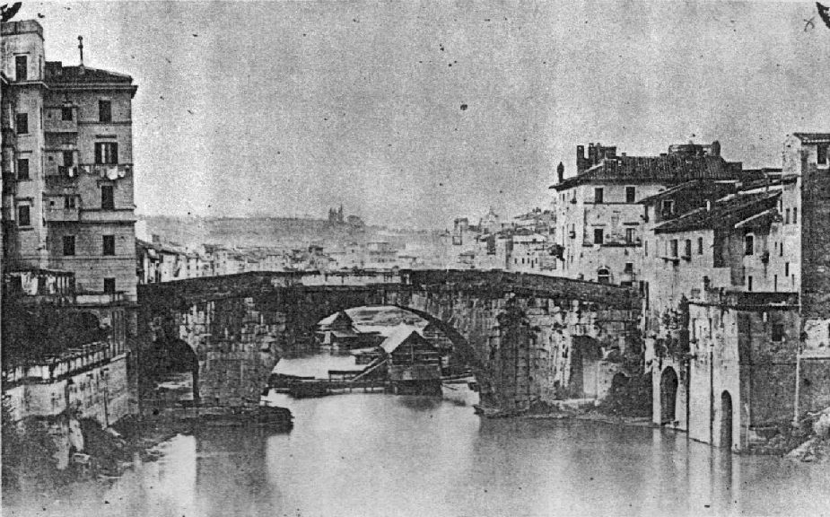
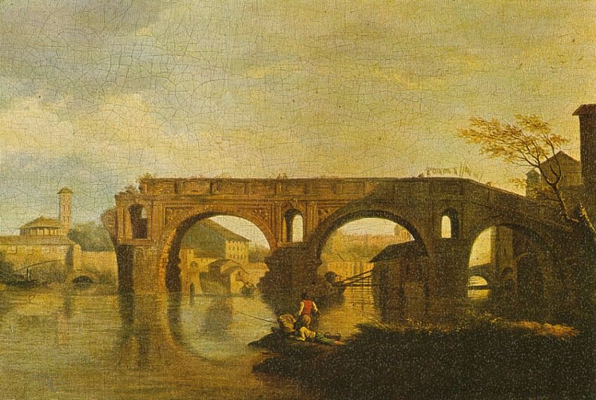
Many more mills have always been in the right branch of the river, due to the river's larger size and greater flow on that side; there the last mills were removed only during the construction of the embankments after the big flood of 1870. The Ponte Cestio was also known as "Ponte Ferrato" [bridge-with-iron] (see pict. E6) for the many mooring chains of the mills around it. Often the mills' moorings were broken by the strength of the current, so it is not unusual to find in the old maps only the masonry ramp without the mill. In the Tempesta map (1593) 4 mills are visible (two mills and a ramp at the island and one moored to the Trastevere bank); in the Maggi map (1625) (pict. C1) three ramps without mills, all of them moored to the island, are shown.
 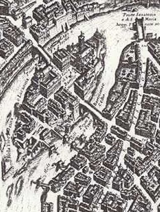 Falda (1676) (pict. C2) shows six mills, two moored to the island and four to the right Trastevere bank; in the Falda map one can also find two facing mills just downstream from Ponte Rotto.
  Nolli (1748) (pict. C3) also shows six mills, three moored to the island and two plus a ramp moored to the Trastevere bank. These locations perfectly match those indicated, two years before (1746), by Chiesa.
In the picture C4, an elaboration on the Lanciani map (1893-1901) are indicated the locations of the various mills obtained from the available documents.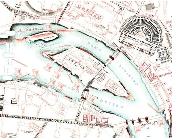
The mills had names, often those of saints; a partial analysis of their locations, limited to the most recent ones, has been possible with the use of existing documents: the "brogliardi
", the maps of the Pio Gregoriano land register, the daily "Specchi Dimostrativi" [Demonstrative Reports] (SD - see also para D) of the Supervision of Grinding and the works of Cialdi and Moroni. The mills were classified according to their administration: those moored to the island were in the administrative Custody of the Island, while those moored to the Trastevere bank were in the Custody of S.Bonosa.
In the table can be found the mentions relevant to the individual mill and the respective year:
| 1823 | 1826 | 1834 | 1838 | 1845 | 1855 |
[1] Cialdi indicates only the presence of 5 floating mills on the right branch between the island and Trastevere, plus one on the bank (it is the mill with foundations Giuditta mentioned at paragraph B) |
|
|
Fonte |
SD | SD | SD | Cialdi | Moroni | ||
|
|
[3] |
[4] |
[1] |
[2] |
In the "brogliardi" and in the maps of the Pio Gregoriano land register only the urban blocks are recorded;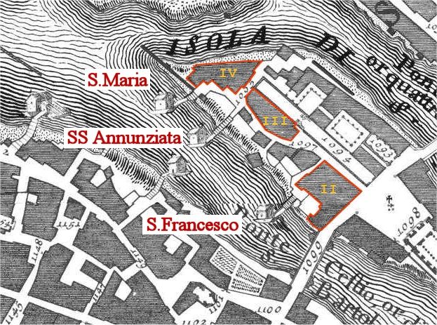 however, as the sentence: "...in front of the mill of..." is often indicated in the records, it is possible to identify the mills of S.Francesco, SS.Annunziata and S.Maria located respectively "in front of" blocks II, III and IV of the island (see pict.C5 from the 1748 G.B.Nolli map).
Finally, as the Acquaroni engraving that represents a mill downstream from Ponte Cestio moored at Trastevere (see picture E4) may be dated around 1820, this mill can be identified as the S.Agostino mill, given that, at that time, the S.Nicola mill was still moored to the island.
D) DESCRIPTION
The mills consisted of two floating rafts: on the main one, nearest to the bank, were located the millstones inside the characteristic small house, often with a cross on the top. Between the two rafts was supported the bladed wheel. The working principle is shown in the animation carried out at the Technical College Meucci in Rome. The rafts were moored to the banks by long chains; a masonry ramp and a wooden footbridge allowed access to the bank (pict. E1 e A3).
In every mill four workers were normally employed: two "loaders" that brought the grain and the flour with beasts of burden, a "servant" that worked at the millstone and was assigned to repairs and a generic "boy" for various services.
In a mill about 4500 kg of grain per day were ground and the production was daily recorded by the food administration; we have this data from  1823 to 1845 (pict. D1).
The Roman millers located the religious see of their corporation, "Romana Molendinariorum", in the S. Bartolomeo church on the Tiber Island, building a chapel decorated with images of their activity (pict. E9); a plaque still commemorates one of the many restorations of the chapel (pict. D2).
The mills obstructed the normal water flow of the river and often the strength of the current broke the moorings and dragged the mill downstream with disastrous results. As early as the middle of the 1700s it was proposed that they be moved downstream from the town and in 1870 the Public Works Ministerial Commission included the floating mills among the causes of the Tiber floods in Rome. After the big flood of December 1870 and the successive construction of the embankment the Tiber mills definitively disappeared.
E) THE IMAGES
|
E1 |
 E2 |
 E3 |
 E4 |

E1 - This picture probably shows the SS Annunziata mill moored to the Tiber's right branch upstream from Ponte Cestio. On the left is shown the main raft connected to the bank by a masonry ramp and a wooden footbridge. In the foreground is the mooring turret of another mill (probably the San Francesco mill) located downstream (Chaffourier 1870)
E2 - This picture was taken from Ponte Rotto; the island is on the right. Upstream from Ponte Cestio one sees the San Francesco mill in the middle of the arch, the SS Annunziata mill just behind; a third mill in the background obstructs almost completely the right branch of the river (Chaffourier 1870)
E3 - Upstream from Ponte Cestio are visible, moored to the island, the SS Annunziata mill and, in the middle of the picture, the San Francesco mill (Chaffourier 1870)
E4 -The mill downstream from Ponte Cestio moored to the Trastevere bank; at the left are visible the beasts of burden passing on the footbridge. Behind the bridge we see part of the San Francesco mill (Antonio Acquaroni ~1820)
 E5 |
 E6 |
 E7 |
 E8 |
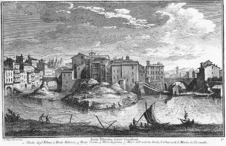
E5 - "Isola Tiberina verso occidente" [Tiber Island's west side]. On the left branch, upstream from Ponte Fabricio, is shown the ramp of the Sant'Andrea mill also known as "Ghetto mill"; on the right branch in the foreground the Santa Maria mill, the partially hidden SS Annunziata and San Francesco mills moored to the island and two more moored to the Trastevere bank (Giuseppe Vasi 1754)
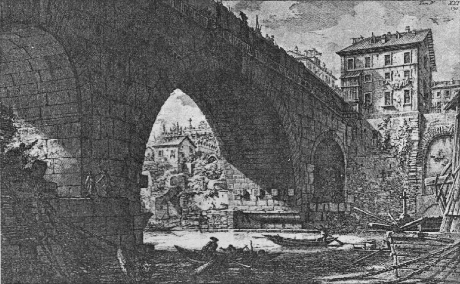
E6 - "Veduta di Ponte Ferrato degli Antiquarj detto Cestio" [View of bridge-with-iron of the "antique dealers", called Cestio]; fantasy view from the island upstream from the bridge (G.B. Piranesi, middle of XVIII century)
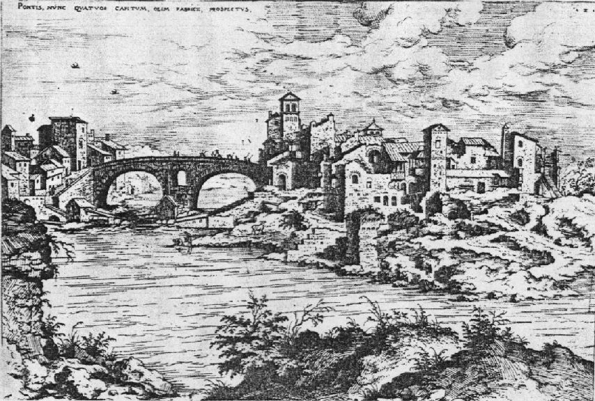
E7 - The Tiber Island and the Tiber's left branch with Ponte Fabricio and two mills; the left one is probably the mill "Sant'Andrea al portone delli Hebrei" [mill of S.Andrea at the Door of the Jews]. (Hieronymus Cock 1530-34; see also B2)
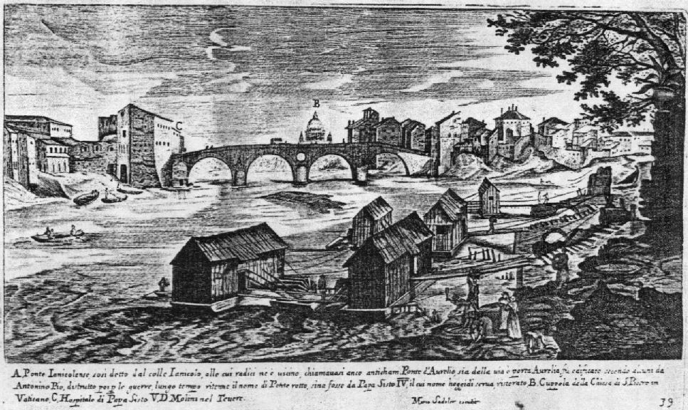
E8 - Fantasy view showing several mills downstream from Ponte Sisto (Hieronymus Francken, inc. M.Sadler - copy from a Du Perac 1574 dwg.)
 E9 |
 E10 |
 E11 |
 E12 |
E9 - Images of the mills painted on the ceiling of the Chapel in the San Bartolomeo church, on the Tiber Island, where the corporation of milled established their religious see
E10 - In this painting from the end of the XIX century is visible, behind the arch of Ponte Cestio, the ramp of the old Ghetto mill (St Andrea)
E11 - This painting represents a view seen from the east end of the island which shows a mill and its relevant access ramp behind Ponte Rotto (anonymous - end of the XVIII century)
E12 - A millstone dug out from the river bed and exposed at the Ripa Grande port. It is possible to see the characteristic "guzzatura" i.e. the grooves carved by skilled craftsman in order to permit the proper grinding of grain. As soon as it was carved a millstone tended to become packed with grain and required a preparatory period of grinding before it produced in a satisfactory manner.
F) BIBLIOGRAPHY AND CREDITS
[1] Cesare D'Onofrio "Il Tevere" - Romana Società Editrice - 1980
[2] AAVV "La nave di Pietra" - exibition catalogue - Electa - 1983
[3] Gaetano Moroni "Dizionario di erudizione storico - ecclesiastica da S. Pietro sino ai nostri giorni" - Tipografia Emiliana - Venezia, 1855
- Pictures A1 and A2 courtesy of Katherine Rinne
- Pictures E10 and E11 courtesy of Kalervo Koskimiehen
The realization of this section was made possible thanks to the essential contribution of the book:
Umberto Mariotti Bianchi
Roma Sparita: I molini del Tevere
Ediz. Babuino - Roma 1976
English translation check by Karen Bermann
